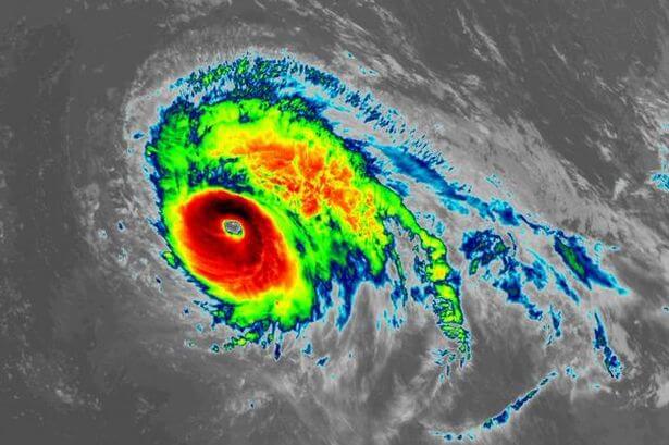
National Hurricane Center forecaster Eric Blake unveiled Lorenzo became a Category 5 hurricane almost 650 miles farther east as compared to the previous easternmost Category 5 hurricane, Hugo in 1989.
Well it’s official. #Lorenzo has made category 5 with 160 mph sustained winds. Crazy it made it almost ten degrees (600 miles) east of the previous easternmost cat 5 Hugo! https://t.co/u4tAWTcGMP pic.twitter.com/ifQ5TW3cPH
— Eric Blake 🌀 (@EricBlake12) September 29, 2019
According to Colorado State University tropical scientist Dr. Phil Klotzbach, Lorenzo also had the lowest pressure for a hurricane east of 50 degrees west longitude on record Saturday evening and has been a major hurricane for the longest period of time east of 45 degrees west longitude on record.
Lorenzo was the second Category 5 hurricane of the 2019 Atlantic hurricane season and the sixth such high-intensity hurricane to form in the Atlantic ocean in a little less than three years, after Matthew, Irma, Maria, Michael, and Dorian.
The National Hurricane Center (NHC) mentioned Lorenzo’s radius of wind is large, raising the concerns it may influence the group of Portuguese islands about 900 miles west of Portugal.
Lorenzo’s wide circulation is intensifying swells over much of the North Atlantic Ocean that will trigger dangerous tides on the beaches of the East Coast of the United States, many Caribbean islands, the Bahamas, Bermuda, western Europe, Atlantic Canada, and even western Africa over the next few days.
Here’s one way to show #Lorenzo’s large size- the wave field is absolutely massive. The light blue (2m or ~ 7 ft) contours cover almost the whole area north of 20N- swell reaches the US and the UK. The magenta is significant wave heights > 15 meters (50 ft)! pic.twitter.com/5jLrjNhi4Y
— Eric Blake 🌀 (@EricBlake12) September 29, 2019
Heavy downpours from Lorenzo may lead to life-threatening flash flooding in the Azores late Tuesday into Wednesday.
Eric recently warned that the hurricane-force winds can be destructive.
Good example with #Lorenzo tonight of how you need to look at more than just the cone. The wind speed probabilities tell you much more about the actual hazard than the tiny cone, which is just the center. When the hurricane-force winds are wider than the cone- beware! pic.twitter.com/ITJeWAgDZz
— Eric Blake 🌀 (@EricBlake12) September 30, 2019
According to NOAA’s historical database, only seven Category 2 or stronger hurricanes have tracked within 200 nautical miles of the Azores in a record from the mid-19th century.











Leave a Reply